But an advantage to being on a frontier is that we can get out into the wilds pretty quickly. In 20 minutes, in fact, and on the way we had to drive through a 1,000 acre forest while technically still in the city (like the 100 Acre Wood, it contains bears).
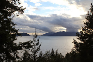
The other side of the bridge from the Vancouver peninsula you quickly join the Trans-Canadian Highway, which has an evocative enough name itself, but when it hits the Pacific you turn right onto the Sea-to-Sky Highway. And now you're in the middle of nowhere. Forested mountains, their tops already dusted in snow, drop to the waters of Howe Sound, and equally rugged islands with names like Anvil and Keats sit on stormy waters under grey skies. Signs warn you to carry snow chains beyond this point (which we didn't) and others instruct you not to stop because rocks will fall on you.
It was all a bit breathtaking. Luckily in Lions Bay we found a lovely tea room and inhaled again thanks to a cup of English Breakfast and a morning glory muffin. The whole road is 250 miles long, and I don't much fancy driving it when the snow comes down. "This is just a tiny chunk of the vast massiveness!" commented Hannah poetically. Never a truer word.
I shall not be attempting to learn the Squamish language any time soon.
Round the corner from Vancouver, and here we are.
Totem poles aren't things that are worshipped, they record the history of a particular place. Unfortunately that stone to the left is where they'll put the explanation, so I'm not sure what happened here yet.
I did all that work on the Sea-to-Sky Highway Improvement Project and still they spell my name wrong.
Yep, plenty of sea and sky.
It's 900 miles to the nearest road?! Then I remembered that we're metric up here.
I think that might be Bowyer Island.
Hannah, tea, muffin.
Someone still doesn't entirely appreciate his snow suit.

A final view on the way home to relative civilisation.


